| |
|
|
|
|
| |
The Protest |
|
|
|
| |
|
|
|
|
| |
Big Trees Destroyed |
|
The Treesit |
|
| |
The Parking Lot |
|
FROG "Ribbits" |
|
| |
Friends of Cathedral Grove (FROG) |
|
Habitat Encroachment |
|
| |
|
|
|
|
| |
|
|
| |
|
|
|
|
| |
The Parking Lot
People from around the world come to see the big trees of Cathedral Grove, spectacular constituents of the temperate rainforest that not long ago proliferated on Vancouver Island in British Columbia (BC). The only ancient Douglas fir forest that is easily accessible to tourists, Cathedral Grove is bisected by the Alberni Highway. The Highway causes grave ecological damage to the tiny park and is a traffic hazard, serving as a defacto parking lot for the millions of tourists who stop to gawk at the big trees (right). To profit from the popularity of the big trees, in 2001 and again in 2004, the BC government announced plans to build a five acre parking lot for 200 cars & campers, 50 tour buses and 30 RVs, as well as a restaurant and souvenir shop. This plan for further habitat degradation was rejected by environmentalists. |
|

Cathedral Grove, 25 May 2008
Vancouver Island, British Columbia |
|
| |
|
|
|
|
| |

"Paving paradise for a parking lot" (Click to enlarge)
Times Colonist, 4 August 2001 |
|
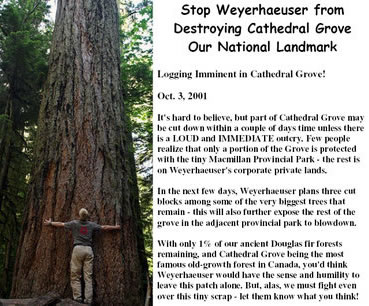
Save Cathedral Grove "Paving paradise for a parking lot" is the often quoted line from a 1970s song by Joni Mitchell that has become the epitome of an ongoing environmental battle.
When the BC government first revealed its parking lot scheme in 2001, forest activist Ingmar Lee wrote a protest letter to the newspaper (left): "Cathedral Grove is the last representative stand of primaeval forest in southeast Vancouver Island's coastal Douglas fir biogeoclimatic zone. 80 percent of this ecosystem . . . is owned by two logging corporations which are cutting the remaining patches of these ancient forests. The first half of this vast forest, which once grew trees larger than the California redwoods took about 120 years to log. The remaining half has been mowed down in the past 30 years." |
|
| |
|
|
 |
|
| |
The letter by Ingmar Lee (above) was illustrated with a photo of a giant stump, the waste left over from a logging operation by Weyerhaeuser in the critical buffer zone of Cathedral Grove in 2000.
Filmmaker and activist Phil Carson explained: "This isn't just about a parking lot. All the adjacency issues are already well documented: the changes to the hydrology from the brutal clearcuts above the park, the wind damage from the clearcuts adjacent to the park, the ongoing devastation of endangered animals, fish and plant communities, the devastation of First Nations cultural sites . . . the parking lot was just the last straw."
Stop Weyerhaeuse, Cathedral Grove, 2000
Photo: Rick Methot
|
|

Weyerhaeuser logs, Cathedral Grove, 2000
Photo: Rick Methot
Soon after Weyerhaeuser bought out MacMillan Blodel in 1999 the BC government negotiated a trade whereby the logging corp got a tract of forestland in Strathcona Park in exchange for about two hectares on the windward southern side of the big tree stand. To extract maximum lucre from the land before the trade, Weyerhaeuser continued clearcutting it during the negotiations, building a logging road and mowing down two huge stretches of profitable old growth trees. The spectre of an ancient log dump at the edge of Cathedral Grove (above) angered forest activists and consolidated opposition to further destruction. |
|
| |
|
|
|
|
| |

"Parking lot development" (Click to enlarge)
British Columbia Ministry of Environment |
|
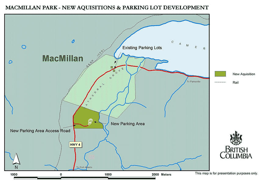
The dark green area on the map (left) is the two hectare plot of logged land traded by Weyerhaeuser to the BC government for a parking lot development. Space for 200 vechicles, 20 buses, a restaurant, septic system and an interpretive centre were planned for a projected one million visits per year. The idea had been initiated in 1992 with minimal public consultation and did nothing to solve the real traffic problems caused by a busy commercial highway which bisects a popular nature destination.
A more pragmatic and long term solution to reduce traffic congestion and increase park safety was first proposed in 1991. Broadly supported by environmentalists and Port Alberni residents, it was based on the construction of an alternative highway route for non recreational traffic and commercial vechicles through an already clearcut valley to the north of Cathedral Grove. |
|
| |
|
|
|
|
| |

Valley and mountain topography of Cathedral Grove
Wilderness Committee |
|
|
Key to coloured areas:
Light green – Cathedral Grove
Yellow – planned site for new parking lot
Blue – Cameron Lake
Middle green – Qualicum Falls Prov. Park
Dark green and red – High elevation slopes
Heavy black line – Highway 4 to Port Alberni
White – Mount Arrowsmith massif |
Surveyors in the early 20th century laid out a road that passed through the heart of Cathedral Grove with no concern for its ecological integrity. Today the Alberni Highway (Highway 4) is the sole transportation route to between Port Alberni on the west coast and Parksville on the east coast of Vancouver Island. The highway is located in the narrow valley bottom, and as the topographical map shows, the terrain rises steeply on both sides of it (left). Parking along the highway in Cathedral Grove is dangerous, primarily because of the heavily loaded logging trucks that pass through and do not reduce their speed. |
|
| |
|
|
|
|
| |

Driving through Cathedral Grove (Click to enlarge)
Vancouver Island, British Columbia
Cathedral Grove is one of the few places in the world where an ancient temperate rainforest can be readily seen off the highway (above). Its popularity has created a traffic hazard, especially as the speed limit of 60 mph is not generally observed. The frustration of forest and park activists who are forced to defend Cathedral Grove from both the logging industry and the BC government is expressed by the sign created by FROG member Richard Dean (right) for a rally held on 23 October 2008 at Cathedral Grove to protest the latest encroachment by Island Timberlands (aka Brookfield, formerly Brascan, Weyerhaeuser, MacMillan Bloedel). |
|

"CUT, LOG, PAVE For Pay-To-Park"
Sign by Richard Dean, 2008
|
|
| |
|
|
|
|
| |

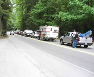
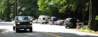
Highway parking, Cathedral Grove (MacMillan Provincial Park), 2 February 2009
Vancouver Island, British Columbia, Canada |
|
| |
|
|
|
|
| |
 |
|
"Where are them Big Trees? . . . You're parked on them."
Cartoon by Adrian Raeside ridiculing the parking lot plan for Cathedral Grove |
|
|
| |
|
|
|
|
| |
Although it has been over half a century since the government declared Cathedral Grove a provincial park in 1939, the dangers to the longterm survival of the big trees continue unabated. As John Muir, founder of the Sierra Club, wrote about the Giant Sequoias he campaigned to protect: "God has cared for these trees, saved them from drought, disease, avalanches, and a thousand straining, leveling tempests and floods; but he cannot save them from fools."
Over a century after John Muir expressed his sentiments in 1897, they were echoed by Jill Thompson of the BC Chapter of the Sierra Club of Canada in relation to Cathedral Grove: "Once again this government is being reckless with our natural heritage. This is one of the most accessible and magnificent examples of temperate rainforest in the world. Building a parking lot in this forest stand is like installing a drive through in Notre Dame Cathedral." |
|
Traffic in Cathedral Grove, 2007
Vancouver Island, British Columbia |
|
| |
|
|
|
|
| |
|
Cathedral Grove – Bisected & Degraded Over 100 Years |
 |
 |
1912 – unpaved wagon road |
1939 – with phone poles |
 |
 |
1951 – widened asphalt highway |
2004 – tourist congestion |
|
|
| |
|
|
|
|
|
An historical compilation of photos of Cathedral Grove, from 1912 to 2004 shows the ever increasing impact of the road through the heart of the big tree stand (above). Initially it was little more than a single track wagon road, built in 1907. By 1939 the importance of Port Alberni as a lumbering town had greatly increased along with the population, and the road was widened. Note the scale of the telephone pole behind the automobile. In 1942 it was named the "Alberni Highway" and in the early 1950s it was further widened, paved and renamed "Highway 4." Although continually widened ever since, the highway has proved inadequate for the ever increasing commercial, local and tourist traffic and the government declared a crisis in 2004.

"Physiography of MacMillan Park Area"
British Columbia Government |
|

Cathedral Grove park boundaries
British Columbia Government
The government has long known that the physiography of "MacMillan Park" was not appropriate for a major thoroughfare (left and above). Yet Highway 4 was developed as the sole route between Port Alberni and the east coast of Vancouver Island. No regard was given to the ecological effects of the exponential increase of traffic through the centre of Cathedral Grove. |
|
| |
|
|
|
|
| |
In 2002 the E&N Railway (bought by RailAmerica Inc. in 1999) from Port Alberni to Parksville was abandoned, making the highway the sole source of transportation for timber, pulp and wood products from Port Alberni (right). Most trucks carry heavy double loads and, as they descend the steep mountain on the highway section known as the "Hump" into Cathedral Grove, the drivers are reluctant to slow down and wear out their engine brakes. The big trees attractions of Cathedral Grove are located on either side of Highway 4, but crossing the busy road is a dangerous and frightening experience for park visitors due to the many speeding vechicles. The enforcement of a low, safe speed limit is an obvious but unpopular solution, not yet implemented. |
|
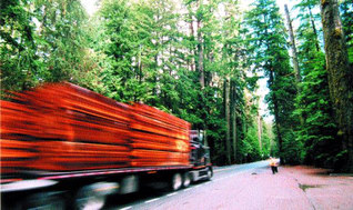
Truck with lumber from Port Alberni, 2006
Cathedral Grove, Vancouver Island |
|
| |
|
|
|
|
| |
 |
|
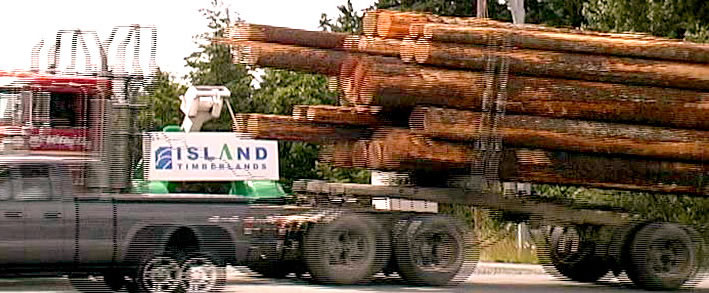
Island Timberlands truck on Highway 4 transporting raw logs from Port Alberni to
export depots on the east coast of Vancouver Island, 5 October 2005
|
|
|
| |
|
|
|
|
| |

Logged areas (red), Cathedral Grove
Wilderness Committee
The above map also shows the "MacMillan Addition" to Cathedral Grove (yellow) in which the government planned to build a five acre parking lot (brown). No consideration was given to the 2001 proposal to increase the size of the protected landbase to the north of Cameron Lake and on the Cameron River floodplain (right): "Not only would additional park land for Cathedral Grove be part of our plan, but wildlife and recreation corridors would be created" Annette Tanner, Western Canada Wilderness Committee. |
|
The so called "traffic safety" problem caused by congestion in Cathedral Grove is not caused by a lack of parking facilities but rather by a lack of traffic calming measures. The government's 2004 decision to build a five acre parking lot is a scheme designed to benefit primarily the logging industry by taking the tourist vechicles off the highway.
The Wilderness Committee has been a vocal oppenent of the government's parking lot proposal, when in 2001 it was first announced and when in 2004 it suddenly reappeared, once again without proper public consultation. A map of Cathedral Grove (left) shows how the clearcut logged tracts (red) on the windward side have impacted the big trees by creating wind tunnels that produce blowdown areas (pink).

Proposed park addition (Click to enlarge)
Wilderness Committee |
|
| |
|
|
|
|
| |

Save Cathedral Grove Petition, 2001
Wilderness Committee
A petition to Save Cathedral Grove (above) that circulated in 2001 was signed by over 10,000 people, yet the BC government chose to ignore the call for more protection for the endangered big trees (right). The Friends of Cathedral Grove (FROG) support the wildlife corridor plan in which the entire Cathedral Grove Watershed would be protected so that it forms a biogeographical continuity between the Beaufort Mountain Range to the north, the Clayoquot Sound Biosphere Reserve to the west, and the Mt Arrowsmith Biosphere Reserve to the east. Cathedral Grove would thus become a unique natural monument of endangered primaeval temperate rainforest ecology, embodying the goal of UNESCO (United Nations Educational, Scientific and Cultural Organization) to reconcile nature conservation and biodiversity with sustainable human use. |
|

Big tree, Cathedral Grove, 2004
Photo: Ingmar Lee |
|
| |
|
|
|
|
| |
The BC government organized a surprise public meeting to discuss Cathedral Grove on 25 October 2004 in Port Alberni. Despite the short notice, those present included Hupacasath Chief Councillor Judith Sayers, Western Canada Wilderness Committee and the Friends of Cathedral Grove (FROG).
The government's parking lot plan was rejected by the public in favour of the long standing proposal that has been under review for 30 some years to reduce traffic congestion in Cathedral Grove by rerouting Highway 4 via a new connector road from Port Alberni and Horne Lake to the east coast of Vancouver Island. FROG submitted an alternative plan which uses an existing clearcut area (right). This area is located close to Cathedral Grove so that none of the existing forest buffer need be sacrificed: Parking Lot Solution.
|
|

Cathedral Grove Parking Solution.
Friends of Cathedral Grove |
|
| |
|
|
|
|
| |
Not far from Cathedral Grove, the sawmill town of Port Alberni has been polluting the Alberni Inlet for over a century. Sawmills and huge pulp and paper factories spew toxic chemicals the air and contaminate the water (right). As a result, the once abundant wild salmon have all but vanished. Bisected by Highway 4 from Port Alberni, Cathedral Grove is never free from the deafening roar of huge commercial trucks transporting lumber and raw logs to dockyards in Nanaimo for export (below).

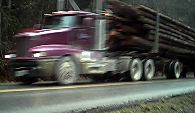
MacMillan Bloedel truck, Alberni Highway
Cathedral Grove, Vancouver Island, British Columbia |
|
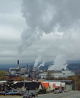
Pulp and paper mill, Port Alberni, 2004
Photo: Karen Wonders
The photo on the left is described by a logging industry enthusiast: "Lindquist Freightliner Unit #8 with a load of western red cedar from MacMillan Bloedel's Somas Division in Port Alberni east bound through Cathedral Grove, Vancouver Island heading for the BC Ferry Terminal at Duke Point." |
|
| |
|
|
|
|
| |
Speeding log truck from Port Alberni
Cathedral Grove, Vancouver Island |
|
Highway parking, 2006
Cathedral Grove, Vancouver Island
The real problem is not caused by tourists parking in Cathedral Grove (above), but by the large volume of commercial trucks transporting raw logs and lumber from Port Alberni through the popular big trees park at excessive speeds (left). |
|
| |
|
|
|
|
| |
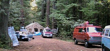
Forest protection camp, Cathedral Grove, 2004
Photo: Ingmar Lee
Public safely issues caused by the high level of traffic through Cathedral Park and lack of parking facilities are red herrings used by the government to distract attention from the true underlying problems. The message of the 2004 forest defence action in Cathedral Grove was clear: Weyerhaeuser Go Home! (right). Old growth logging in BC must be banned; Cathedral Grove must be expanded; and the highway through it rerouted. Instead this irreplaceable natural heritage is being mismanaged by park authorities who are subjecting the precious ecosystem – which is already severely damaged due to human intervention – to short term economic profit schemes including a 200 car parking lot, a restaurant and a souvenir shop. Meanwhile the real culprits (Island Timberlands, Brookfield, Brascan, Weyerhaeuser, MacMillan Blodel) who have destroyed the Cathedral Grove Watershed and removed the buffer zone protecting the big trees are going without punishment. |
|
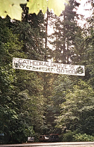
"Weyerhaeuser Go Home," 2004
Photo: Krista Roessingh |
|
| |
|
|
|
|
| |
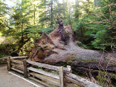
Fallen giant, Cathedral Grove, 2007
Vancouver Island, British Columbia
Cathedral Grove is an international nature treasure and the highlight of scores of tourist visits to BC (right). The stand of gigantic trees is the subject of countless photographs, but few visitors recognize how endangered the tiny park is. Industrial logging has devasted the entire Cathedral Grove Watershed, removing the protective buffer zone of the big trees and leaving them prone to blowdown (above). |
|

Norwegian tourists, Cathedral Grove, 2004
Photo: Nils-Kristian Moller |
|
| |
|
|
|
|
| |

Big tree marked for destruction, Cathedral Grove, 2004
Photo: Scott Tanner |
|
On 9 February 2004 Annette Tanner, chairperson of the Mid Island Chapter of the Western Canada Wilderness Committee, discovered that the BC government had surrepticiously moved ahead with its parking lot plan by sending in a logging crew into Cathedral Grove. An industrial grapple yarder is seen behind a doomed old growth Douglas fir marked by a pink ribbon (left). Once the alarm had been sounded, concerned citizens joined the protest against the logging operation. It is shocking that the BC government plans to destroy even a small part of the primaeval forest type represented by Cathedral Grove, when less than one percent of it survives across the southern BC and Washington State landscape that it once dominated – before the age of industrial foresty and its rapacious pillaging. |
|
| |
|
|
|
|
| |
The misguided government plan to lay waste to part of the irreplaceable habitat at Cathedral Grove has rallied widespread opposition. "The solution for Cathedral Grove," wrote environmental journalist Stephen Hume, is to "Leave the trees alone. Leave the fish alone. Leave the river alone. Put the parking lot well outside the boundaries in an existing clearcut above the flood plain. . . Is this simple solution too complicated when it comes to ensuring protection for a sensitive and threatened ecosystem?"
Hume makes the point that the Douglas fir ecosystem represented by Cathedral Grove (right) is rapidly vanishing: "more than 99.5 per cent has been extirpated by loggers, developers, road builders, housing contractors, shopping malls and, of course, parking lots . . . Yet 72 per cent of the parking options proposed for this picturesque postage stamp of a park – it is already bisected by Highway 4 – would have an impact on the unique forest. It's called Cathedral Grove because a sense of the sacred is evoked by the immense old growth" 9 December 2005, Vancouver Sun:
Just Leave the Trees Alone.
|
|

Ancient Douglas fir, Cathedral Grove
Photo: Carol |
|
| |
|
|
|
|
| |

Rootball of fallen giant, Cathedral Grove, 2007
Vancouver Island, British Columbia |
|
The varied forms of habitat degradation are well known; the government has produced at least a dozen management plans for "MacMillan Provincial Park" over the past two decades, many of them containing scientific data on comparative impacts on the vegetation. "Blowdown" (left) is largely due to the barbaric clearcut logging of so much of the Cathedral Grove Watershed by MacMillan Bloedel et al. This deliberate removal of the vital forest buffer zone that protected the big tree grove from hurricane force Pacific wind storms continues today, motivated by commercial greed.
Also well known: the planned location of the parking lot is a floodplain that is regularly submerged (below). Contaminated runoff, culverts and drainage diversions are detrimental to riparian habitat and fish. Huge quantities of hard fill redirects natural water flow behind stagnant dams and upsets the natural balance. |
|
| |
|
|
|
|
| |

Flooding in Cathedral Grove, January 2005
Photo: Annette Tanner |
|

Flooded protest camp, January 2005
Photo: Annette Tanner |
|
| |
|
|
|
|
| |

Wetland forest, Cathedral Grove
Photo: Richard Boyce |
|
In February 2004 the BC government quietly resurrected its 2001 plan to construct a parking lot in a wetlands area of Cathedral Grove subject rich in forms of life. FROG member Richard Boyce described the habitat (left): "Here I have counted seven species of ferns growing amongst salmon berry, cascara, thimble berry and Nootka rose. The occasional thicket of devil's club grows out of the rich black soil of the bottom lands surrounded by fragrant stink current and red elderberry. Lichens and mosses hang from the lower branches and trunks of most trees. The thick fluted bark of the dominant trees, ancient Douglas fir, provides nesting for small birds such as the winter wren and Pacific flycatcher. The variety of tree species, age, thickness and height creates a forest that is truly diverse, abundant with life and death."
|
|
| |
|
|
|
|
| |

Blowdown caused by clearcutting, Cathedral Grove
Photo: Richard Boyce
Logging in the Cathedral Grove Watershed has resulted in significant damage to the course of Cameron River. In 1990 storm runoff, flooding and high winds resulted in six hectares of blowdown and erosion. In 1996 high winds caused dramatic tree top breakage and blowdown (right). Further degradation by park visitation compacts the soil over sensitive root systems and damages the vegetation. |
|
The proposed parking lot in Cathedral Grove and the road and trails will create dike like structures, making the giant trees more susceptible to root rot, and destroying more the primaeval forest habitat that the park is supposed to protect. The park is already surrounded by clearcuts that channel the powerful "Qualicum" storms into the heart of the grove, levelling giants which might have survived past a thousand years of age (left).

Blowdown, Cathdral Grove, 2008
Vancouver Island, British Columbia |
|
| |
|
|
|
|
| |

Parking lot location, Cathedral Grove, 2005
Photo: Anthony Maw |
|
At the last minute – in November 2005 – the government bowed to public pressure and created the appearance of a public process on its website under the disingenuous title "MacMillan Provincial Park Safety Enhancement Project."
Perceptive critical commentary was forthcoming: "The matter in contention has been not so much where to build a parking lot, but whether to build one at all. Many visitors and those who view the park in photographs online are not only reacting to the majesty and astounding stature of the trees; they are stunned and angry at the scenes of wanton excess and butchery on the surrounding clearcuts; many express pain and shock at how small a remnant has been left for them, for wildlife, for the trees themselves"
Valhalla Wilderness Society. |
|
| |
|
|
|
|
| |

Clearcut logging, Horne Lake
Vancouver Island, British Columbia
In 2004 the BC Ministry of Transportation commissioned the "Horne Lake Connector Study" (right). The alternative highway (marked in turquoise) was estimated to cost $40 million. Instead of pursuing this option, the government chose the cheaper option of upgrading the existing highway (marked in red) which bisects Cathedral Grove and in 2005 the steep slope known as the "Hump" (marked on the map) was widened to make it more easily navigable for heavy commerical trucks serving the Port Alberni forest industry.
In 2007 the Alberni Clayoquot Regional District formed a "Connector Road Committee" to promote the construction of a new highway. Surprisingly, no effort has been made to reopen the E&N Railway (marked in black), which ended services in 2001 after Catalyst Paper Corporation stopped transporting its products by rail from Port Alberni. |
|
Compare the semi protected Cathedral Grove Valley with the adjacent Horne Lake Valley which continues to be clearcut logged (left). Horne Lake is the location of an alternative 26 km "connector" highway from Port Alberni to the east coast of Vancouver Island that would diminish commercial traffic through Cathedral Grove. Locals describe it as a "zoo" due to the congestion caused by tourists who come to gawk at the big trees.

Horne Lake Connector Study, 2004
Ministry of Transportation (Click to enlarge) |
|
| |
|
|
|
|
| |
|
BC Government Officially Abandons
Parking Lot Plan . . .
"I can confirm that the entire 301 hectares is protected
as a Class A Park. The Ministry of Environment has no
current plan to build a new parking lot in MacMillan
Provincial Park" R. H. Heath, Environmental Stewardship
Manager Vancouver Island Region, 12 July 2007 |
Above: On 5 April 2006, the government finally announced that it had abandoned its contentious parking lot scheme: "With the implementation of traffic calming measures, BC Parks will no longer be proceeding with the construction of a new parking lot in Cathedral Grove." At the request of FROG, a formal confirmation followed on 12 July 2007.
But the battle for Cathedral Grove is continuing: immediately after the climbdown by the government in 2006, the Western Canada Wilderness Committee launched its campaign to "Protect All Of Cathedral Grove." This would include the 400 some hectares of private forestlands to the west of the Grove and another 900 hectares of ancient and mature forests lie on public (Crown) lands to the east of the Grove on the north side of Cameron Lake. Most of all the local communities are fed up with having huge international corporations determining their livelihoods. Greedy short term profiteering has wrecked community watersheds and caused grievous ecological damage to the once abundant temperate rainforest, ruining the resources of future generations. |
|

Highway parking, Cathedral Grove, 2007
Vancouver Island, British Columbia |
|
| |
|
|
|
|
| |
Anti Weyerhaeuser protest banner on Alberni Highway at the FROG protest camp, 2004
Cathedral Grove (MacMillan Provincial Park), Vancouver Island, British Columbia |
|
| |
|
|
|
|
| |
©
Credits & Contact |
|
| |
|
|
|
|